Research & Science

Through a robust interdisciplinary scientific inquiry, C-CHARM investigates the effects of climate change on geohazard risks and energy infrastructure in the Western Upper Peninsula of Michigan’s local communities, with an emphasis on formulating adaptation and mitigation strategies. 

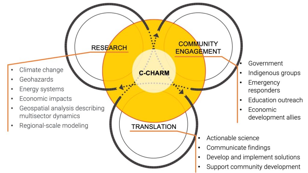
The core of C-CHARM’s scientific inquiry is shaped by a set of science questions derived from various disciplines. 

Climate Change and Climate Extremes

  • How do interactions between the Great Lakes, the atmosphere, and land under the warming climate impact coastal microclimates and extreme events? What impact would the warming climate have on summer storms and winter lake-effect snowstorms? 
  • How will the projected warmer future climate modify the wind and wave climatology near the coast? 
  • How will long-term future changes in precipitation and river runoff impact the water levels of the Great Lakes?

To explore the impact of a warming climate, we utilize a state-of-the-art fully 3D two-way lake-atmosphere-land coupled regional climate modeling system. This modeling system is a two-way coupling between the Weather Research and Forecasting (WRF) model coupled and a Great Lakes hydrodynamic and ice model based on the Finite Volume Community Ocean Model (FVCOM). This coupled modeling system, along with future climate simulation technique such as the Pseudo-Global Warming (PGW) approach, is utilised to simulate the future Western Upper Peninsula climate and examine the evolution of variables and extreme events under a warmer future climate. For example, we simulate how extreme summer storms, such as the Fathers Day Flood storm of 2018, could look like in the warmer future climate as this serves as a good demonstration of the impact of climate change on the Western Upper Peninsula of Michigan’s extreme events. 

Geohazards

  • How will the changes in climate extremes affect the watershed hydrological response and associated geohazards, such as floods and landslides?
  • What barriers do rural communities face in geohazard risk reduction? How can rural communities leverage climate change-induced extreme weather projections to mitigate geohazard risks?

Geohazard modeling aims to evaluate the changes in risks linked to various natural disasters, such as floods and landslides, which are expected to worsen due to variations in extreme rainfall patterns in an increasingly warm climate. The flood risk modeling method involves the application of the flood risk assessment tool in the Rural Hazard Resilience Tools (RHRT). This tool integrates the Height Above the Nearest Drainage (HAND) model and National Streamflow Statistics (NSS) model, and the risk assessment functions in the HAZUS program of the Federal Emergency Management Agency (FEMA). The landslide risk assessment is based on changes in the safety factor, due to rainfall infiltration, using a simple infinite-slope model. These approaches are utilized to assess the changes in risks related to floods and landslides in projected extreme rainfall characteristics compared to the current rainfall patterns, which will help build climate-resilient communities in the Western Upper Peninsula.

Energy Infrastructure

  • How does the transition of electric power systems toward decarbonization and electrification impact the vulnerabilities of rural communities? 
  • How can multi-sector models incorporate regional-scale climate modeling results and local-scale geohazard identification to facilitate the planning of resilient energy services?

The vulnerability of energy infrastructure to climate change and geohazards will be quantified using physically-based models for events like flooding, extreme heat, and snow that affect the supply of electricity (reducing the capacity of transmission and generation) and the demand for electricity (increasing the magnitude or changing the timing of peak demand events). We illustrate energy vulnerabilities through a set of scenarios, selected based on community input, to describe the vulnerabilities of electricity infrastructure created or mitigated by energy transitions, regional climate change, and local geohazards. 

Socioeconomic Baseline, Economic Impact, Natural Capital Analysis

  • What is the local socioeconomic baseline and how can regional climate change impacts be modeled within a natural capital framework? 
  • What is the local economic impact of power system transitions and flood risk mitigation?

Regional economic impacts of scenarios informed by the energy infrastructure and geohazard work across the project will be evaluated with IMPLAN, an economic modeling and data software. In particular we will focus on the employment, production, and tax implications of power system transitions and flood risk mitigation.  Additionally, we will work to map the outcomes of the geohazard and energy transition analysis to the natural capital framework.  Taken together, these efforts will provide a picture of the impacts to households and natural resource values in the region. 

Community Engagement and Co-production Exchange

C-CHARM is grounded in and informed by community engagement, ensuring that our goals are conceptualized and activities are organized based on community needs and priorities. 

Community Co-Production Team (CCPT) meetings are held quarterly throughout the project to understand our community’s needs and priorities. These meetings facilitate discussion among community leaders from different sectors and specialties to identify the most prominent concerns our communities are facing. These discussions are themed around areas of local susceptibility regarding geohazards and energy vulnerabilities, while also identifying who, where, and what relationships, strengths, and opportunities already exist. The feedback of the CCPT  is used to develop the scientific approach to build more enduring physical, technical, and social assets to support community resilience in the face of a changing climate. This process is repeated iteratively throughout the project to cater to the materials being developed by the project team specifically to the needs of the community.   

Existing Tools